Monday, January 29, 2018

The Lonely Sailor of Ceann Iar

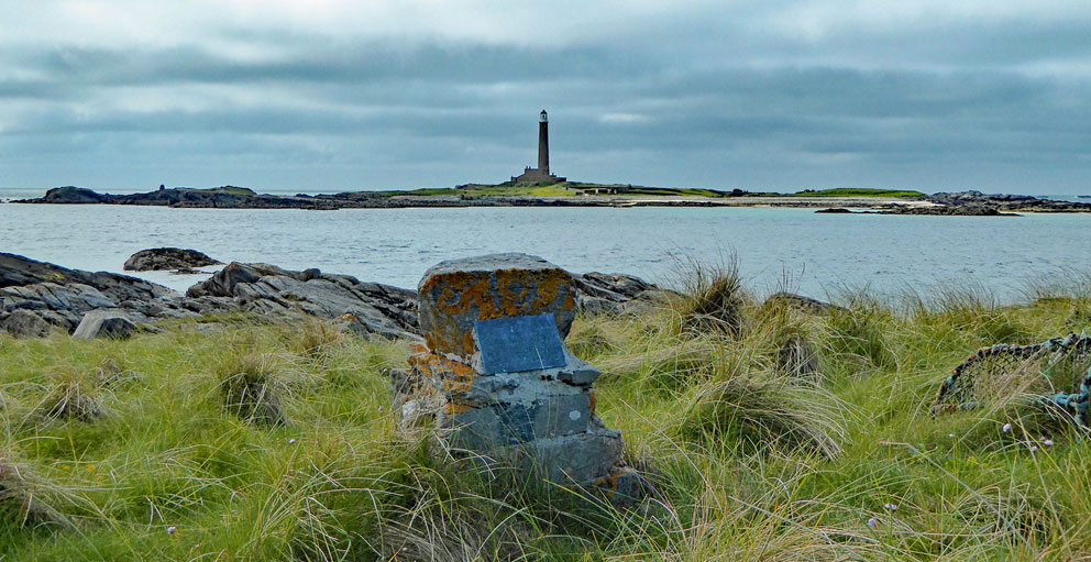
A lonely cairn lies on the western tip of Ceann Iar of the Monach Isles. It marks a grave that is occasionally visited by day-trippers during the spring and summer. But most of them know nothing about the history of the man who's buried in this lonely spot.


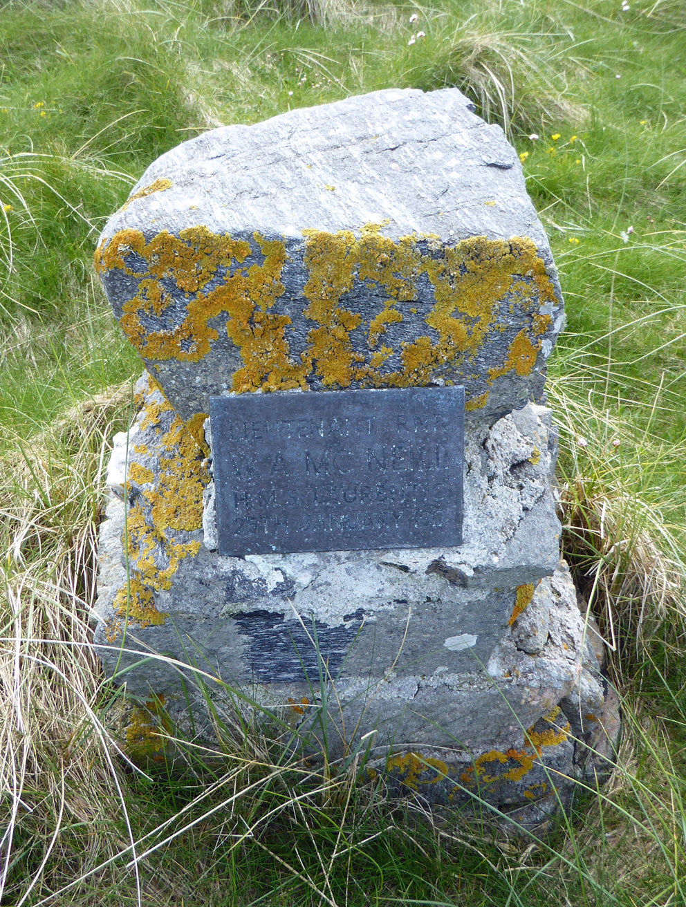
A metal plaque embedded in the cairn reads:

LIEUTENANT RNR 
W.A. MC NEILL
HMS LAURENTIC
25TH JANUARY 1917

Lieutenant William McNeill died when his ship, HMS Laurentic, hit mines off the coast of Donegal, 150 miles due south of the Monachs. Some of the story of Lt McNeill, and a drawing of the Laurentic, can be found at this link. More of the lieutenant's story came to light last week when I was contacted by a relative of William McNeill who lives in British Columbia. Here is the information he provided. 

* * *

Lt. W.A. McNeill was born on April 14, 1881 in the Free Church Manse, in Holm parish, Orkney Islands, Scotland. He was the eighth child of sixteen born to Rev. D. McNeill, MD and his wife. William or “Willie” as he was referred to by his family and friends, always had a love for the sea and ships and had to be a sailor.

Shortly after completing high school, around 1900, he went to sea with the merchant navy. In the early years of his career, he attained his Master’s Certificate and became a ship’s officer. He served as an officer on RMS Lusitania for a period shortly before she was sunk on May 7, 1915.

Lt. McNeill was a senior officer on HMS Laurentic when she struck two German mines and sank off Lough Swilly, Northern Ireland on January 25, 1917. Lt. McNeill was one of more than 350 men that were lost.

After a period of time, Lt. McNeill’s body washed up on the shore of Ceann Iar of the Monach Isles, some 150 miles from where he had perished. It is said that the fisherman who found him exclaimed “a McNeill has come home!” as the Outer Hebrides are the ancestral home of Clan McNeill. There is an unconfirmed story that, at roughly the same time, the body of a German submarine officer was washed ashore near the same place, and that the two bodies were buried side by side in two plain coffins made of wooden boxes. It is said that the locals remarked “We buried them together, for in death they were both the same.”

A few days after Lt. McNeill was lost, on January 31, 1917, his younger brother and closest sibling, Sgt. Patrick McNeill died of what was believed to be pneumonia. He had just returned to England after twenty months of combat in the trenches of France and claimed to have not had dry feet in over three weeks.

Lt. McNeill left behind a wife, 18 month old daughter, father and several siblings, one of which was a relatively well known Scottish author, F. Marion McNeill.

* * *

If you ever make it to the Monachs, be sure to walk to the west end of Ceann Iar. There, on a lonely point of land nearest to the island of Shillay, stop for a while and pay your respects to Lt William McNeill, a man who gave his life for his county 101 years ago this month.

Monday, January 22, 2018

Eva Alaire Calhoun (1927-2018)

Today my mother, Eva Alaire (Sneed) Calhoun, lost her year-long battle with cancer. Among many things, she instilled in me a love of family, and family history. Without her extensive research into our family history in the 1970s and 80s, I would have never known of my Scottish roots. Neither would I have made my first trip to Scotland in 1989, when my wife and I, accompanied by my parents, spent a few weeks there. It was during that trip that I first set foot on some of the Isles of the West, including Mull and Iona. 

Mom on Main Street - Iona
Mom was not able to travel in recent years, and so when I was in Scotland I would always climb to the top of an island, turn on the mobile phone, and hope to get a signal so I could call her. On those times when I could get through, she would be delighted to hear from me as I described the scenery, and what I was up to. I will miss her.

Mom on the machair - Iona

Mom and Dad in 1955

Saturday, January 20, 2018

Lismore Ridge Walk

Even though I've only done it once, the Lismore Ridge walk is an amazing day-out. The right way to do it is to spend a few days on Lismore, so you can take your time, wait for good weather, and then enjoy the walk at a relaxed pace. It is possible to do it as day trip from Oban, but you will always be thinking about making the last ferry. Although I call it the Lismore Ridge, it is actually a series of limestone ridges: Druim Mor (big ridge), Garbh Dhruim (rough ridge), and Druim nan Damh (deer ridge). 

When I made the walk I was staying in a B&B at Achinduin, at the south end of Lismore's west-side road. I set out on foot from the B&B early in the morning, then, after paying a visit to the ruin of Achadun Castle, I headed cross-country to the south, avoiding the top of Druim Mor until I reached Tom na Faire (look-out hill), at the southern tip of Lismore.

Achadun Castle
From the top of Tom Na Faire there is a direct view south to Eilean Musdile and its lighthouse. This particular island is seen by thousands of people every year from passing ferries, but it is rarely visited.  In the next photo, just beyond and to the left of the lighthouse, you can see Lady's Rock. This was where one of the chiefs of Clan Maclean is said to have stranded his wife, the daughter of the Earl of Argyll. He left her there to drown, as the rock is submerged at high tide. As one version of the story goes, she was rescued and the Campbells had their revenge. 

Eilean Musdile and Lady's Rock seen from Tom na Faire.

Eilean Musdile - Tom na Faire on Lismore to the right
From Tom na Faire I turned north to start the ridge walk to the north. There are many hills with "Faire" in their Gaelic names, which means "watching". And many of the 'Fairy Island', or 'Fairy Hill' place-names you come across are incorrect English translations of the name.

The next two hours of walking was magic as I made my way up the spine of the island; amazing sea-views in all directions.


Along the way you can also see low-lying Eilean Bernera off to the west; also know as Bernera of the Noble Yew. See this link for descriptions of visits to Bernera.

Bernera
As you continue north, placid Loch Fiart appears down the slopes to the east. Having covered nearly three miles you eventually reach Lismore's highest point, the Barr Mor.

Loch Fiart

Atop the Barr Mor
Many years ago, I've lost track of when, I was inspired to visit Lismore and climb the Barr Mor after reading Campbell Steven's The Island Hills (1955). It is a charming book, and one that every Scottish island-lover should read. In it, the author has this to say of the climb up the Barr Mor:

It provides no meal for the mountianeer, not even a boulder problem to whet the cragsman's appetite. It is in fact a real lazy man's paradise, like Iona's Dun I, or Windy Hill on Bute; the way to its cairn, from whichever direction one approaches, is no more than a stroll. Yet your Lismore resident is as proud of his hill as any Chamoniard of Mont Blanc.'

Looking southwest from the Barr Mor 
From the Barr Mor you can descend west to Achinduin, or east to the main Lismore road at Kilcheran. Kilcheran is an interesting place. It was a Catholic college for 30 years (1792-1822), and more recently the last home of Isabel Bonus (1875-1941), who illustrated many of MEM Donaldson's books. See this link for a photo of Kilcheran House.

When I made the Lismore Ridge walk I descended west from the Barr Mor to return to the B&B at Achnaduin to complete one of the best island hikes I've ever made. The hospitality of the Walkers, who ran the B&B, was wonderful. Unfortunately the B&B is no longer running, so I have no recommendations on a place to stay. But a long visit to Lismore is a must. So take a look at the Lismore Accomodation website, pick a place, and go explore.

Monday, January 8, 2018

Round Towers

Round towers are iconic, and interesting structures. Serving as a bell-tower (and possibly a place of refuge), many have survived intact for centuries. The first one I visited was at Ardmore in the south of Ireland, where I was disappointed to find that the interior was off-limits to the public. Oh how I wanted to climb that 100-foot tower, like the monks of old, to enjoy the view over Ardmore Bay.

Like Ardmore, most of the intact towers are locked up, but in the years since that visit to Ardmore I have been able to climb a couple in Ireland that are open to the public: Kildare and Devenish Island.

Kildare - a tourist waving from the top
Top of Kildare

Devenish
Built between the 9th and 12th centuries, there were about 120 round towers in Ireland, 20 or so still  in good shape. Outside of Ireland there is one at Peel on the Isle of Man (Man's closest point to Ireland), and three in Scotland: Brechin, Abernethy and Egilsay. Of the three Scottish towers, the only one you can climb is Abernethy. Unfortunately Brechin is locked up tight, and the tower on Egilsay is hollow.

Brechin
Inside  Egilsay tower

Abernethy Tower - tourists waving from the top
There is another Scottish round tower I've climbed: a miniature replica built in 1914 on Canna. There are no floors inside Canna's tower, just a series of stones embedded in its wall that can be used to climb to the bell.

Canna tower

Inside Canna tower
There is one more round tower replica in Scotland that deserves mention. Built in 1912, it commemorates a turning point in the history of the islands, and Scotland: The Battle of Largs.

Largs Tower
The round tower of Largs stands 60 feet tall, and overlooks Largs' Marina. I paid a visit to it after spending several days exploring the Cumbrae islands. As I approached the tower along the shore path I had hopes I could climb it, but once I stood below the padlocked door, which was 10 feet above the ground, it was readily evident that that was not going to happen. Even though it was off limits, the entrance was amazing, as they replicated the exquisite stone doorway carvings of the Brechin tower.

Brechin doorway (1990)

Largs Doorway
Later I would learn from Magnus Magnusson's Scotland: The Story of a Nation (2000) that, even if I had the key and a step-ladder, it's not possible to climb the Largs tower:

The only access is through a pad-locked oaken door, two and a half metres off the ground. Inside, there is absolutely nothing, apart from a generous legacy of guano, bequeathed by the local pigeons who use the memorial as a convenient dovecote. There were originally four wooden floors, which allowed access by ladder to the 'look-out' floor at the level of the small window at the top, but the flooring has long since been removed for safety. 

The Battle of Largs was a significant turning point in the history of the isles. I like the perspective put on this by Don Alick 'Splash’ MacKillop in his Sea-Names of Berneray:

When we, in the Western Isles, lost the Battle of Largs, it spelt the beginning of the end of the Norse influence in these islands, and all that is left today is their language in place-names and their blood in the veins of the islanders.


Don Alick (Splash) MacKillop - RIP: 1931-2009
In the words of Splash, despite the Battle of Largs, Norse blood, and place names, still figure prominently in the isles.

Wednesday, January 3, 2018

Scenes from Killegray

Killegray, in the Sound of Harris, is an interesting, but rarely visited island. I have only been there once (see chapter 15 of book 2). I believe the name means either "Island of the Church", or 'Burial Place Island". At its north end is Teampull na Annait, the site of a medeaval church and burial ground. (The place-name Annait signifies it was an early Christian site.)

This is the description of Killigray from the Ordnance Gazetteer of Scotland (1882-4):

Calligray or Killigray, an island in Harris parish, Outer Hebrides, Inverness-shire, nearly in the middle of the Sound of Harris. It measures about 2 miles in length and 1 in breadth; is nearly all deep uncultivated moss in the south end, but consists of good cultivated land in the north end; and is inhabited by a people who are mainly supported by fishing. Faint traces of a very ancient building, supposed to have been a heathen temple, are in its north end


My visit was a day trip that started with a three-mile boat ride from Leverburgh. The boatman nosed his small boat into a reef on the shore below Killigray House, where it was easy to get ashore. The house here dates to the late 18th century, and is in fine shape these days.


Behind the house is a later addition, an excellent design that fits well with the original house.


Next to the house is a stone gateway; its pillars topped with stone balls, nearly identical to the sea-gate in front of the house on nearby Ensay. How I wished I'd taken a picture through the Killegray gate that showed more of the sea, like I'd done through the sea-gate on Ensay.

Killigrey gate

Ensay gate
From the house I headed north to what the old Ordnance Gazetteer called a heathen templeTeampull na Annait. 

Looking towards Pabbay from Teampull na Annait
There's not much left of the medieval church and burial ground that once stood here; just a low rectangular outline in the turf, with several small, stumpy tombstones poking up here and there. You can read the CANMORE page on it here. A while back one of the graves was exposed by the sea. Its occupant was found with a hammer and scales. One theory for this is that the hammer was for the dearly departed to knock at the door of heaven, and the scales so that the weight of their soul could be determined. The Jethro Tull song Two Fingers comes to mind:

I'll see you at the Weighing-In
When your life's sum-total's made.
And you set your wealth in Godly deeds
Against the sins you've laid.

Nearby is the holy well known as Tobar na Annait. I looked for it, but could see no sign of a well anywhere. Later research showed that the well lies a quarter mile to the south, and is now used as the water supply for the house. (You can see a photo of the well here.)

Looking to Ensay from Teampull na Annait
From the old graveyard I walked down the west side of the island, enjoying the views to the many islands in the sound: The pyramid of Pabbay the most distinctive of them all.

Pabbay on the horizon
Killigray beach is a half-mile stretch of sand facing to the northwest. I believe that back in the day the queen picnicked here on occasion. No royals were about, so I had the whole beach to myself.


A slight wander inland took me to placid Loch a' Mhachair.


The next photo shows some of the cultivation ridges that cover much of the island. Like Ensay, Killegray had about 300 acres of arable land.


Halfway down the coast, sitting on a tidal mound 60 feet from the shore, was the fortress of Dunan Ruadh; bits of its defensive wall still discernible. There are quite a few forts named 'Dunan Ruadh' in the isles, and you can see a list of them all here. The word 'ruadh' can mean: red, reddish, strong, dried or scorched. Perhaps scorched is a reference to being vitrified; the walls exposed to fire to fuse them together.


From the fort I wandered down to the south end of the island, a marshy area that was wet to walk through, so I turned back north. The terrain in front of me was beautiful; rolling green hills surrounding the elegant house. Ten years or so ago there were talks of building a highway link from Berneray to Leverburgh. A two-mile causeway would link Berneray to Killigray; then a  short bridge to Ensay; then a mile long connection to Harris. I do not know if the project is still under consideration, but if it came true a highway would bisect the amazing terrain in the next photo.


From the south end I made the short climb to the top of the island. Crowning the summit is an extraordinary cairn, one I've not see the like of on any other island. It was partly hollow, with an opening at the bottom. I was told this was so you could build a fire inside the cairn. If you are ever stranded on Killigray, you can call for help from here the old fashioned way - if, that is, you can find any wood.


I had another 30 minutes until pickup, so I spent them sitting next to the cairn, enjoying the view over all the islands in the sound. I also enjoyed a beer.